www.overlandturkey.com/turkey-tours
Cultural Trekking Routes in Turkey, Turkey Walking routes, GR footpath Turkey, Turkey Trekking Routes
Turkey has 20 long-distance trekking routes and Overland Travel Agency is operating tours in all of them. Overland Travel agency gives you some information about all trekking routes. Four of these cross international borders and continue into other parts of Europe and Asia. There are hikes for all tastes: from breath-taking scenery to historic roads and ruins, rugged wilderness to local village life. Guided tours are available along several of the walks. We provide information about the routes, accommodation options, transportation, and links to guidebooks and maps as well. If you like to trek, we are here to help you for your best private trekking tour
All Routes:
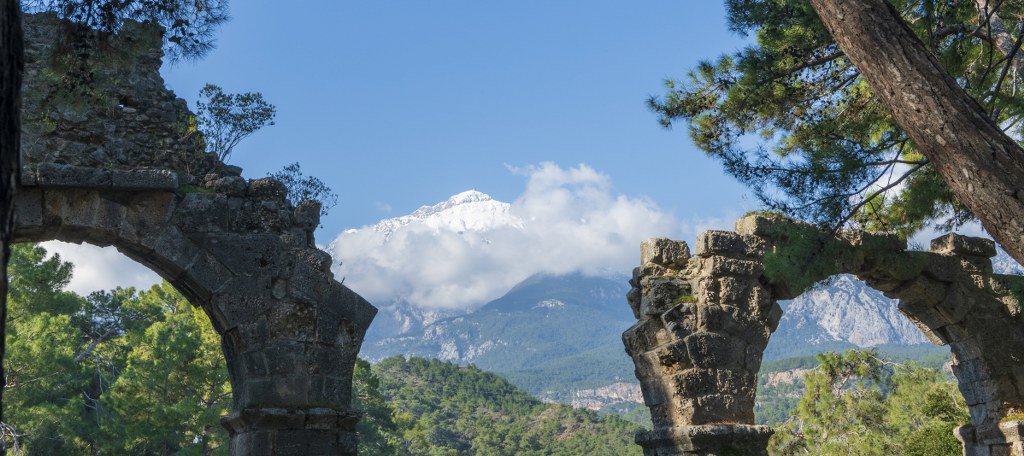
Lycian Way
Turkey’s first long-distance trekking route Lycia is the historical name of the Tekke Peninsula, which juts into the Mediterranean on Turkey’s southern coast. The mountains rise steeply from the rocky coast, giving beautiful views and varied walking. Forestry predominates; pines are mixed with strawberry trees and carob, and give way to juniper and cedar at higher elevations. Along with coastal tourism, high-intensity agriculture is crowded onto the deltas.The Lycians were a democratic but independent, warlike people, with a developed art style and a high standard of living. Their strategic position gave them unique opportunities for sea-trade and (at times) for piracy. After Persian rule, the Lycians welcomed Alexander the Great and absorbed Greek culture. Later, Lycia became a province of the Roman Empire. The Romans developed many cities and ports, linking them with paved roads and equipping them with theatres, baths, forums, temples and ceremonial gates. From the 4th Century, Christianity took hold and, as the Roman empire crumbled, many Byzantine monasteries were founded in the Lycian hills. Lycian graves and ruins abound on the peninsula and the Lycian Way passes about 25 remote historical sites.
Lycian Way
European 1950 Datum Equidistant Cylindrical Map:lycia] A coastal walk through history – Turkey’s first long-distance route
The Lycian Way is a 540 km, 29-day way-marked footpath around the coast of Lycia in southern Turkey, from Fethiye to Antalya. The trail consists mainly of Roman roads, old footpaths and mule trails, often hard and stony underfoot, not suitable for mountain bikes. Lying between the coast and mountains, it often has steep gradients. It was researched, designed and waymarked by Kate Clow, a British/Turkish amateur historian, in 1999. Turkey’s first long-distance walking route, it was made in order to identify and protect some of Turkey’s old roads.
The start point, at Ölüdeniz, is 2 hours from Dalaman airport and the end point is now at Geyikbayırı, from which there are daily buses to Antalya. We are working on a link to the St. Paul Trail, which will open in 2019. If you want to walk this 10-day connection route now, please mail us. In addition, at three places along the trail are groups of local walking routes, marked in yellow and red. These are: the Fethiye trails, Kemer Trails and Konayaaltı Trails
There is good public transport all along the trail and opportunities to swim, canoe or paraglide. Trekking is best in spring or autumn – February-May or September-November – summer in Lycia is too hot for long walks. Except for 3 high-level sections, every night you can find accommodation in village houses, pensions or small hotels. Independent trekkers will find plenty of wild camping places with nearby water.
The Carian Trail is an 800 km long distance walking path exploring Southwest Turkey through the modern provinces of Muğla and Aydın. The trail is named after the Carian civilization. On route you will discover a region rich in ancient ruins and history. Stone paved caravan roads and mule paths connect villages from the coast to a mountainous hinterland. Pine forest cloaks the mountain slopes whilst olive terraces and almond groves are an important part of the region’s economy.
The trail accesses a lesser known and unspoiled region that is full of colour and tradition for all to enjoy. The trail is signed and waymarked according to international standards allowing both independent and group travellers to hike and enjoy the scenic beauty and cultural treasures of Caria. A guidebook and a map is available, which gives the best detailed information about the route and region.
Swim in turquoise waters from deserted beaches, climb through pine scented forests to discover ancient ruins, look out over a dramatic coastline across to the Greek islands of the South Aegean. Rare mountain goats still roaming the remote forests of the Datca peninsula, boat building in Bozburun, Neolithic cave paintings of the Bafa region, traditional village carpets woven by village girls; all this and more awaits the hiker in search of new adventure
St Paul was responsible for the spread of Christianity to Western Europe. Jesus’ message, aimed at amending the Jewish religion, was preached exclusively to the Jews of Judea and Jerusalem. But Paul took this message to both the Jewish diaspora (those living outside Israel) and also to the worshippers of the traditional gods of the Greeks or Roman Empire, or of other cults. In the process he changed the religion of Christianity, partly by adding many instructions about forms of worship, partly by changing the message (especially regarding women). Paul had no standard text; he also had never met Jesus personally. Thus he was able to interpret Jesus’ message quite freely. If St Paul had not preached, Christianity would probably have died out when the Jewish rebellion of 66 AD was crushed and Jerusalem burned.
Thus Paul was both a product of his time and a major influence on our time.
The St Paul Trail is a 500km 27-day way-marked footpath from Perge, 10 km E of Antalya, to Yalvac, NE of Lake Egirdir. There is a second branch starting at Beşkonak, the entrance to the Köprülü Kanyon National Park 80km NE of Antalya and joining the first route at the Roman site of Adada. The trail is over Roman roads, footpaths and forest tracks; suitable in places for mountain bikes. It’s a wilder route than the Lycian Way, starting at sea level and climbing up to 2200m, with two optional peaks at around 2800m. Kate Clow opened this route in 2008, to bring tourism into rural Turkey and offer walkers insight into the countryside that Paul traveled through on his first journey through Asia Minor.
The start point at Perge, is close to Antalya airport and the end at Yalvaç, near Lake Eğirdir. Eğirdir is a major transport and accommodation hub on the route. Trekking is best in spring and autumn – July-August is hot. Many nights you can find accommodation in village houses or small pensions, but on longer sections you will have to camp – there are plenty of good places.
Evliya Çelebi was an Ottoman Turkish gentleman adventurer who travelled far and wide for over 40 years. Born in Istanbul, he made many journeys across the sultan’s domains to the frontiers of the Ottoman Empire in the Balkans and the Middle East, and far beyond—to the Habsburg emperor’s seat at Vienna, towards the headwaters of the Nile, and to the Caucasus and Iran. Often he travelled on official business, but also for pleasure. His observations on everyday life in the 17th century are a unique record of his times. Among his many accomplishments, Evliya was a scholar, raconteur, dervish, musican, and linguist. He dubbed himself ‘World Traveller and Boon Companion to Mankind’ and wore a ring inscribed ‘The World Traveller Evliya’. He aimed to describe everything he saw on his journeys, and left a record of his wanderings in 10 large volumes, the Seyahatname, or Book of Travels.
The Evliya Çelebi Way is a must-do trail for walkers and bikers, and Turkey’s first route for horseriders. It mixes history and nature, adventure and relaxation. A few days on the Way can enjoyably be combined with sightseeing in the towns and cities Evliya visited.
The Way opened on the quatercentenary of Evliya’s birth, when UNESCO declared 2011 a year of celebration of his life and work. It follows the early stages of his journey to Mecca in 1671, when he at last found the opportunity to undertake the pilgrimage.
The first phase in establishing the Evliya Çelebi Way was an exploratory 6-week horseback ride in 2009, that re-enacted Evliya’s meandering journey from the İzmit Gulf to the town of Simav—inland from the Aegean city of İzmir—as described in his detailed travelogue. Evliya himself continued to İzmir, and south then east around the Anatolian coast towards his goal. In summer 2010 we made hiking expeditions to define the walking and biking route.
The Evliya Çelebi Way crosses some of the most spectacular and varied landscapes in Turkey, visiting villages far off the beaten track, as well as passing through, or close to, towns and cities of great historical importance in this region where the Ottoman Empire was born. It follows rivers and goat paths, tractor- and forestry tracks, and Roman and Ottoman paved roads. The terrain is rarely difficult. The riding route is around 650km long, and takes about 25 days to complete, plus rest/sightseeing days; the walking route omits some flat sections, and is about 330km long, taking about 22 days to complete, plus rest/sightseeing days.
Sultan Süleyman
Süleyman the Magnificent, Sultan of the Ottoman Empire, invaded Europe from Istanbul to Vienna for the first time in 1529, and then again in 1532. Both times the Sultan and his army failed to conquer the city of Vienna. This was the time the Ottoman empire was at its greatest extent and power and the failure at Vienna started a decline in Ottoman fortunes.
Later at the site outside Vienna where the sultan pitched his tents the Habsburg Emperor built a pleasure castle. That is why the historic Sultan’s Trail begins at the edge of Vienna. The path ends at the tomb of the Sultan, behind the Süleymaniye Mosque in Istanbul.
The Sultans Trail makes use of parts of the E8 and the Donauweg and runs more or less parallel to the Via Comitis (the Roman road to Jerusalem).
The total length of the trail is about 2100 km. The Turkish section is 330 km. In Turkey the route can be done by bike.
The Sultan’s Trail office in Haarlem, Holland, has a pilgrim card which can be stamped at several places along the route in order to get a certificate. The office will provide latest route and GPS information for walkers through its website.
The Sultan’s Trail can be walked almost year round. Some higher parts (like the Bulgarian mountains) are only accessible from May to October. Turkey may be hot in July and August.
Welcome to Between Two Seas
“Between Two Seas” is a four-day walking route in the near west of Istanbul, between the Black Sea and the Marmara Sea, which allows one to experience the threatening transformation of Istanbul on foot. The total length of the trail is 60 kilometres. The route composed of four 15-kilometre parts can also be covered over four separate days.
Layer by layer, the route progresses from the outermost periphery of the city to its centre. It passes through rural and forest areas, and water basins to reach the centre of the city. The trajectory passes through lignite mines, the area earmarked for the new airport, the road leading to the 3rd Bosphorus Bridge, excavation dump sites, industrial sites and housing areas, and also sites of cultural and historical significance such as the Yarımburgaz Cave, which is the oldest settlement in Istanbul, and inner-city vegetable gardens.
“Between two seas” is both a proposal and an invitation. It is an action that celebrates the rhythm of walking which opens the soul to perceive the world. And this action is perhaps the most ‘auspicious project’ that will open a ‘passage’ between the Black Sea and the Marmara Sea.
*Between Two Seas is initiated by Serkan Taycan. Supported by 13th Istanbul Biennial.
Welcome to the Tolerance Way
The Roman Emperor Galerius published the first known edict of tolerance in the world on April 30, 311. With this edict, Christians were given the freedom to worship and the freedom to rebuild their churches providing that they complied with the law. Another feature of the published Tolerance Edict was that it inspired the second edict, which was published in Milan in 313 and expanded to include all religions. By virtue of these two published edicts of tolerance, the foundations of tolerance were laid.
The Tolerance Way is the road to Iznik (Nikaia) from Izmit (Nicomedia); the latter was the only city with the title of Metropolis and the capital at the time when the Edict of Tolerance was published (30 April AD 311). The total length of the Tolerance Way is about 126 km (both walking and cycling routes).
This route was used by the French traveler and ambassador Charles de Peyssonnel in 1745, and by the Canadian botanist Robert Chamber in 1906. In 1955, during the Democratic Party period, the construction of the Iznik Road started via Bahçecik in order to transport the vegetables and fruits of the Iznik region to Istanbul along the shortest route, but it was not finished because of the 1960 Turkish coup d’état.
The historical road between Izmit (Nicomedia) and Iznik (Nicaea), which was in use for at least 1700 years, gave the idea and the name – the Tolerance Way – to our walking and bicycling route of about 126 km, the Tolerance Way.
The Tolerance Way will enable walkers to see nearby historical and natural beauties. It is based on original walking paths lying in the area between Izmit (Nicomedia) and Iznik (Nikaia) where the Romans ruled in antiquity. For detailed historical and cultural information about the route, you may visit
The Phrygians appeared in Anatolia in the 11th century BC, migrating across the straits from Thrace. They settled in the region covering the territories of the present day provinces of Afyonkarahisar, Ankara, Eskisehir and Kutahya. By the mid 8th century BC a vibrant civilisation centred around the capital Gordium (Gordion), present day Yassihoyuk, Polatli County of Ankara, was flourishing.
The legendary Midas was the most renowned Phrygian king. Besides the Phrygian capital Gordium, other important settlements were Pessinous (Ballihisar), and the city of Midas (Yazilikaya). The region was covered with volcanic ashes thrown out by Turkmen Mountain (called Mount Elaphoeis in antiquity), and the consolidated tuff created easily carved rocks. The Phrygians left behind many carved rock monuments in the region. The easily worked nature of the local rock also aided in the creation of ancient roads which are still visible in many parts of the region.
The Phrygians were defeated by the Cimmerians, who migrated from the Caucuses in the 7th century BC, and disappeared from history. Phrygian writing is still to be deciphered, but we knew that they were the inventors of flutelike woodwind instruments.
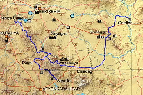
The Phrygian Trekking Route is one of the longest hiking trails in Turkey. Planned with great care for the comfort and enjoyment of hikers, the route passes through the renowned Phrygian Valleys where hikers may visit the ruins of ancient civilisations and enjoy the natural beauty of the region. The Trekking Route is 506 kilometres long, and is marked in accordance with international standards. The Route has three starting points and the trails meet at the Yazilikaya (Inscribed Rock), which was a focal point for the Phrygians. Hikers may start the route at the following points: 1) Gordium (Polatli, Ankara), 2) Seydiler (Afyonkarahisar), and 3) Yenice Farm Ciftligi (Ahmetoglu Village, Kutahya).
The project is sponsored by FRIGKUM (Association for Development and Protection of Phrygian Cultural Heritage) and is completed in 2013 by a small volunter team led by Huseyin Sari. The Route was planned in order to introduce trekkers and byclists to Phrygian culture, and to enable them to enjoy a safe journey through the Phrygian Valleys along trails once used by the Phrygians.
The trail starts at Gordium, the political capital of the Phrygians, then follows the valley of the Porsuk (ancientTembris) River, passes through Sivrihisar (ancient Spaleia), and arrives at Pessinous (Ballikaya), another important Phrygian settlement. The trail then enters the valley of the Sakarya (ancient Sangarius) River, where you enter a completely different world. After the Sakarya Valley, the trail enters the region known as Mountainous Phrygia. The trail then reaches the Yazilikaya, the site of the Midas monument which formed the cult centre of the Phrygians. Here the trail splits into two. One branch leads to Findikli Village passing through the Asmainler, Zahran, and Inli Valleys, once home to Phrygian settlements. This branch terminates at Yenice Farm on the highway between Kutahya and Eskisehir. The other branch passes through Saricaova, a picturesque Circassian village, and Doger, town in Afyonkarahisar. The trail then takes you through Ayazini Town before coming to an end at Seydiler, on the highway between Afyonkarahisar and Ankara. Hikers who complete these trails will treasure the memory forever.
 Practicalities
The best time to trek is spring and autumn, but there are different attractions in all seasons. Along the trail, there are plenty of springs for water year-round.
In 1999 the World Wildlife Fund (WWF) designated one hundred “Hot Spots of European Forests” regions of extraordinary biodiversity requiring immediate protection. The Yenice Forest in Karabük Province, is one the nine “Hot Spots” in Turkey.
The area is a natural wonder, comprising virgin forest, monumental trees, a unique ecosystem, and a wealth of biodiversity rare outside the tropics. Undoubtedly the most important parts of the Yenice Forest are the “Nature Protection Zones” which contain the monumental trees, and the Arboretum area. The protection zone was established primarily to protect the biodiversity of the unspoilt forest, with its many species of monumental trees, the most valuable part of the heritage. The trunks of some of the trees reach diameters and heights that are rarely seen in the world, and grow amid the green valleys, steep summits, and rich plant life created by the abundant water and humidity.
About the Route
The route was created as part of a project instigated by the Governorship of Karabuk and the Administrator of Yenice County in October 2009. 21 trails were marked along 210 kilometres, and together with the alternative trails the total route adds up to 396 kilometres. The trails are classified either as daytrips, short trips or long trips and include forestry roads and footpaths. Mountain bike trails total 292 kilometres. Trail marking is in accordance with the international “Grande Randonnée” system, with red and white paint markers and signposts mark the routes’ beginnings, ends and junctions.
Later the trails are extended to Eskipazar (Karabük) including the ruines of Hadrianoupolis. 8 more paths have been added and the extension project is called ‘Trekking Routes From Nature to History – Eskipazar’
The best season to walk the routes is between April and November.
Kure Mountains Trail
National Park with canyon and forest routes
Küre Mountains
The Wildlife Fund (WWF) criteria for protected sites include integrity of the site, biodiversity, wild life, endemism, rarity, sensitivity, and severity of threats. The Kure Mountains National Park, a unique part of Turkey’s geography, met all criteria. The National Park covers an area straddling parts of Kastamonu and Bartin provinces. The park includes unspoilt land home to endemic plants, fauna, a unique microclimate, interesting geomorphologic structures, deep valleys and gorges, rushing rivers, waterfalls and local culture. The park, covering 370 square kilometres, is truly an open-air museum, and boasts a biodiversity that rivals almost any in the world. The World Wildlife Fund (WWF) selected the National Park as one of one hundred sites requiring urgent protection, and one of nine hotspots in Turkey.
About the Route
The Directorate of Kure Mountains National Park began marking the trekking route as part of an ecotourism project, and the work was completed in 2010. The 482 kilometres long route contains 36 marked trails and, counting alternative trails, the total trail length stretches to 762 kilometres; mountain bike trails measure 828 kilometres. Walkers of varying ability and interests can enjoy short walks, day trips and longer, more arduous hikes. The longest routes require a week of walking and camping. Ambitious walkers can start on the adjoining Yenice Forest trails, hike the whole of Kure Mountains National Park, and finish on the Istiklal Route (Independence Trail), a 500 kilometres long hiking trail which takes a month.
The best season for trekking is between May and November. During the winter the region is snowbound and silently beautiful.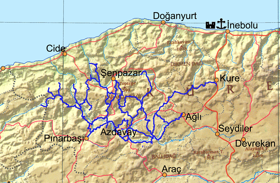
For more information, visit Kure Mountains National Park’s website; http://www.kdmp.gov.tr/default-en.asp
For more information in Turkish, visit http://ersindemirel.blogspot.com/2011/01/kure-daglari-milli-parki.html
Wars of independence give rise to legends and symbols of national rebirth. The Independence Route connects the corners of a triangle which played an important role during Turkey’s War of Independence. During the war, boatloads of arms and ammunition arrived at the port of İnebolu from İstanbul and Russia over a period of three years. A dirt road, built at the end of the 19th century by volunteers and convicts, connected the port of İnebolu to Ankara, and was a vital conduit for military supplies. The famous saying of Mustafa Kemal, “While my eyes scanned Sakarya and Dumlupinar (battlefields), my ears were at İnebolu” demonstrates the importance of the Independence Route, plied by the oxcarts carrying their burdens towards independence.
The Independence Trail follows the old road from İnebolu to Kastamonu. A well-preserved oxcart road between İnebolu and Kastamonu forms part of the route. Of huge historical importance, the famous road also passes through spots of outstanding natural beauty, such as Ersizler Gorge, Karacehennem Pass and Çuhadoruğu peak. A milestone of the struggle for nationhood, the Independence Trail was revived as a trekking and biking course by the Governorship of Kastamonu. Work on the project commenced in April 2007. The most picturesque part of the old oxcart route between İnebolu and Kastamonu, passing through Kure, is perfect for nature lovers. The first ten kilometres of the 105-kilometre route were built as a pathway, and the old oxcart road was repaired over the remaining section. For more information in Turkish,
Day 1: İnebolu-Çuhadoruğu – Stay in Çuhadoruğu village house or camp
Day 2: Çuhadoruğu-Küre Ayrancı Picnic area – camp at Ayrancı
Day 3: Ayrancı-Ecevit Han – stay at Ecevit Han
Day 4: Çatak Gölet transfer – Çatak Göleti-Belören-Ecevit Han – stay at Ecevit Han
Day 5: Ecevit Han-Ödemiş – stay in a village house in Ödemişor camp
Day 6: Ödemiş-Seydiler – acommodation in Seydiler
Day 7: Seydiler-Kastamonu (vehicle transfer for part)
Gastronomy Route
Traditional food and drink of Anatolia
Çorum
Know in Roman times as Niconia, also referred to as Yankoniye, Trokmu and Gordiana, the Greek origin of the name Çorum is Dzorum. According to a study, the name Corum comes from a tribe connected to Üçok branch of the Oghuz Turks.
Çorum, a unique city full of cultural treasures, has a generous nature and has hosted many civilizations throughout history. Of the whole Anatolian peninsula, Çorum has the most traces of the Hittite civilization; and the route between Central Anatolia and the Black Sea maintained its importance in the transition of civilisations througout time. The ancient city of Hattusa is one of the list of the 10 places in Turkey which are Unesco World Heritage Sites.
The 1355 kilometre long Kızılırmak (Red River) passes through 10 districts of the province and gives life to the city of Çorum. The longest river in Turkey, the Kızılırmak greens the landscape of Çorum and links the cultures of the deep valleys of the interior to the Black Sea coast. In contrast to the southern part of the province, which has mountains, deep valleys, lush forests, waterfalls, the natural beauty of the northern part is made up of colored plateaus. Of course, the cuisine reflects the rich cultural mosaic of Çorum.
About The Route
A different concept, used for the first time in Turkey, was used to prepare the Kızılırmak Basin Corum Gastronomy and Walking Route project. In an ecotourism study, the cultural, historical and natural beauty of settlements along the Kızılırmak were evaluated and found to support a unique food culture. Along the route of the river, in the lap of nature, a steady flow of travellers make a ceaseless journey though time and space, borne by the currents of time, spreading this culture.
As a result of the evaluation of Kızılırmak Basin for ecotourism, 190 kilometers of gastronomy and hiking trails are now marked. They are made up of 25 tracks, along with alternative routes, totalling 305 kilometers. Similar to other trails in Turkey, the trails include long walking routes of 37 and 52-kilometer length marked with red-and-white waymarks. There are 7 bicycle routes totalling 606 kilometers, generally following village and forest paths. A 702 kilometer section known as the Scenic Vehicle Road, begins at Hirfanlı Dam, near Kırşehir and passes through Kirikkale, Ankara, Çankırı, Corum, Samsun and Sinop provinces. Those who want to follow the northbound Kızılırmak from the town of Avanos in the province of Nevsehir can use parts of this route parallel to the river to reach the Black Sea littoral. Those who wish to see the historical values of Çorum can follow the 359 kilometer Culture Route. Thus you can, on one journey, pass the ancient sites of Hattusa, Yazılıkaya, Alacahöyük, Corum Museum and the clock tower, Kapılıkaya, Osmancık Koyunbaba Bridge, Kandiba Castle, the Citadel and the Mosque of Hacıhamza Kargi, İskilip Castle and Rock Tombs, Ugurludag Resuloğlu ruins and Sungurlu clock tower. At the same time, all the bike routes and the Scenic Vehicle Road can be combined as a jeep safari route.
While exploring this ecotourism route through the south of the province of Sinop and the north of Çankırı as well as through Corum, enfolded by the lovely Kızılırmak, you have the opportunity to see authentic items of historical and cultural value, crafts and folklore. In addition, you can sample the delights of local traditional delicacies with strange-sounding names, which can not be translated, but which are based on field crops such as beans, lentils, wheat, poppyseed, noodles, stuffed vegetables of many sorts, sweets such as helva.
The route is particularly well suited for hiking in the period between April to November. The highest part of the trail is Kösedağ (2100 m.) which, together with Sakaröküz Hill is under heavy snow in winter.
Best Trails
Karayanık – Waterfalls – Asarkaya
Gökçedoğan Dam Lake – Kızıloluk Picnic Area
Karaağaç Yayla – Mt. Köse – Çukuraluç
Tepelice – Hacıveliler – Kargı Holiday Village
Kargı Holiday Village – Kızılcaoluk Waterfall – Başköy
Yalakyayla – Akpınar
Akpınar – Ahmetçe – İskilip
Recommended 7-day Walk
Day 1 : İskilip-Ahmetçe (7 km), stay in a village house in Ahmetçe
Day 2 : Ahmetçe-Akpınar-Yalakyayla (14 km), camp at Yalakyayla
Day 3 : Yalakyayla-Sorkun (11 km), stay in a village house in Sorkun
Day 4 : Sorkun-Asarkaya-Şelaleler-Karayanık (14 km), stay in a village house at Karayanık
Day 5 : Karaağaç Yaylası-Abdullah Yaylası (10 km), stay in Kargı Holiday Village
Day 6 : Tepelice-Hacıveliler-Kargı Holiday Village (11 km), stay in Kargı Holiday Village
Day 7 : Kargı Holiday Village-Waterfall-Başköy-İkitaş (14 km), stay in Kargı
Hittite Trail
Trek and bike on ancient Hittite roads
The Hittites
The Anatolian Peninsula is a cultural mosaic, a synthesis of successive civilisations that left their mark on this land and on humanity. Of these civilisations, the Hittites were a ‘superpower’ of their times. The Hittites are famous for producing the first written constitution and an advanced criminal code; for making lightweight war chariots, the awesome weapon of the era; for kings who were masters of strategy; for a pantheon with one thousand gods and goddesses; and for splendid cities. The ancient city of Hattussas is one of ten Turkish sites that form part of UNESCO’s World Heritage List. The Hittites also left us extraordinary cuneiform tablets, now part of the UNESCO Memory of the World Register. The Hittite Routes explore the region’s rich cultural heritage amid tranquil surroundings – a truly special experience for lovers of history, culture and nature.
Hittite Map
About the Route
The focal point of the Hittite Routes is a beautiful National Park, established in 1988 over 2634 hectares of land in Boğazkale County. The National Park contains the ruins of the ancient Hittite city of Hattusa and the Alacahöyük earthen burial mound. The Hittite Trekking Routes and Bike Trails follow the historical roads connecting corners of the triangle formed by Hattusa, Alacahöyük and Şapinuva. The routes were drawn up by the Governorship of Çorum and the work was completed in October 2010. The 17 trekking routes covering 236 km. are marked along the old roads plied by the trading caravans and by successive waves of migration. Counting the alternative roads, its total length reaches 385km. Six exciting mountain-bike trails stretch over 406km.
Abraham’s Path follows the footsteps of the patriarch Abraham, whose journey marks the beginning of the Biblical narrative, and the birth of a spiritual and cultural tradition shared by more than half the people in the world today. Join a journey that links history and myth to living cultures and communities: traverse the semi-arid steppes, discover ancient shrines, and trade stories with local host families.
Urfa is a sacred city par excellence, built around a ritual complex of mosques, caves, and blessed carp pools marking the site where Abraham was born. Visitors will follow Abraham’s footsteps through these ancient environs, and explore a mosaic of surrounding sites whose significance stretches both before and after the time of the patriarch. You might start in the capital city Urfa, where you can explore the famed pilgrimage sites of Balikligol and sample some of the city’s celebrated cuisine. Or opt for the biblical city of Harran, where Abraham dwelt with Sarah before travelling on to the promised land of Canaan. The remnants of this era (the Well of Jacob, the city of Jethro) are tucked among the cotton fields and mud-brick homes of today’s Arab and Kurdish villages.
Within a days’ walk of Harran lie several hilltop shrines that rise suddenly from the surrounding plateau; some, like the recently discovered archaeological wonder of Gobekli Tepe, are visible for miles around. This remarkable prehistory is rivaled by Urfa’s historical treasures: the city was once home to pagans, Jews, Christians and Muslims, each of whom lent a distinctive flair to Urfa’s contemporary culture, cuisine, and architecture..
The Kaçkar Mountains are an extension of the Caucasus, and separate the Black Sea from Anatolia. Armenians and Georgians settled early in the Pontic Alps, now the Kaçkar, later building wonderful stone monastery churches hidden in the mountains. The Turks gradually occupied the area from the 11th century but area remained ethnically mixed; Turkish, Hemşin and Laz languages are still used.
The Kaçkar is one of the most bio-diverse areas in the world. It has huge areas of mature evergreen forest, upland pastures once grazed by herds of bulls, three glaciers and many glacial lakes. Since the 1980’s, trekkers have enjoyed the National Park and high mountains but, because of dam-building and mining projects, many residents left for the cities.
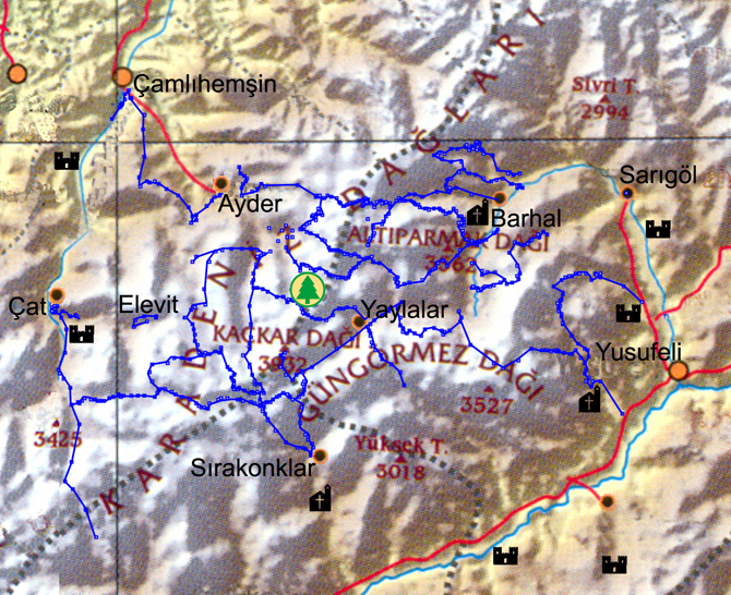 The Kaçkar book contains 8 long hiking trails, using different passes over the main range and ranging from 3-6 days long. Some can be done using local accommodation; for others you require a tent. You could use mule support on some trails. These trails link to each other in various places so can be combined to make longer trips. They are not waymarked, but you can mail us for GPS points. These trails start on inter-village paths often through steep, dense fir and pine forest, then rise to the treeline, which is at about 2100m. Above the treeline, they are easy to find. From the ridges and passes they have superb views over the ranges and valleys. Some routes link villages with high pastures; others are old trade routes; most are steep and some very rocky. All were researched, mapped and published by Kate Clow since 1992.
In addition, the guidebook has 7 waymarked daywalks in the Hevek valley, from Olgunlar to Barhal. These are intended as family walks that can be done early or late in the season, when the main trails over the passes are still closed by snow. Some of the pensions have leaflets with maps and walking notes for these trails.
The most popular trek is the climb of Mt Kaçkar at nearly 4000m. Lower daywalks and parts of routes are open for 5-6 months, but, unless you use snowshoes, summits and routes across high passes are only open July – September. You can hire mules and drivers to carry baggage for extended treks. There is accommodation in larger villages and plenty of water and many wild camp areas.
The routes on the south are reached from Erzurum, and on the north from Trabzon (both have main bus stations and airports); Artvin also has a major bus station. Daily public buses connect towns and villages.
Mount Ararat (Ağrı), the highest point of both Turkey and Europe, can be seen from vast distances across the eastern Turkish plain, rising ethereally into the clouds. In 2004, it was declared a national park. Its summit, snow-capped all year, is a dormant volcanic cone covered with glaciers, the largest permanent ice-mass in Turkey. Its mention in sacred texts, in the context of the story of Noah’s Ark, makes this massif unique. Claimed to be “impossible to climb” by the famous explorer Marco Polo, for many years this majestic mountain haunted the dreams of adrenalin-addicted explorers. The cone of Mount Ararat is surrounded by several summits higher than 3000m. The slopes of all these mountains are covered with basalt blocks and lava flows, blown out by ancient volcanic eruptions. They harbour a variety of birds and rare wild flowers as well as small lakes.The area attracts mountaineers and nature lovers with several well-known mountaineering routes. Known as the “roof” of Turkey, the province of Ağrı includes four of Turkey’s highest summits: Greater Ararat 5137m., Mount Süphan 4058m., Lesser Ararat 3896m., Mount Tendürek 3533m.Süphan’s summit is in Bitlis but the north-eastern slopes are located within Ağrı province. Ararat walking routes include Greater Ararat, Lesser Ararat, Mount Süphan, Mount Köse summits and Balık and Küp high tarns. The province of Ağrı was once part of the early Urartu kingdom, famous for immense fortifications and superb metalwork. These fortresses, plus the luxurious 17th century İshak Paşa Palace, nestle amongst snowy peaks and await discovery by both nature and history lovers.
Sarıkamış Trails
Expanding over high plateaus found at altitudes of 1500 through 3000 metres, Sarıkamış falls to the southwest of Kars Province. Located at the edge of Kars Duzu (Kars Plain) besieged by Mounts Allahuekber, Soganli and Gullu, Sarıkamış is at the spot where the Anatolian peninsula transitions to Caucasia (Transcaucasia region). The settlement bears all geographical characteristics of Eastern Anatolia Region and its lands demarcated by Selim and Senkaya townships of Erzurum Province) from the north, Horasan and Eleskirt townships (of Erzurum) from the south, Selim and Kagizman districts from the east and Senkaya and Horasan population centres from the west.
In a geography where these protruding surface contours form deep corridors, there exist such canyons as Keklik, Komdere and Inkaya. These canyons are covered with dense and lush Scots pine forests, which are also identified with the name Sarıkamis and are renowned for their beautiful layouts.
About the Route
Mainly, routes are concentrated on two regions; Sarikamis and Susuz Valley. Being one of Turkey’s major ski centres,Sarıkamış impresses her guests with her spectacular beauties. This cute little town of the east, where you will feel the comfort and warmth of a friend’s house, presents a real tourism potential with its natural and historical heritage. In addition to its existing winter tourism dynamics, Sarıkamış aims to bring together nature-lovers with alternative tourism activities.
Sarıkamış trails reach a total length of 256 kilometres in aggregate, on 21 different routes. On these trails which effectively use the valleys of Keklikdere, Komdere and Inkaya, as well as the generic Scots pine forest texture any nature-lover is welcome to walk comfortably and without any hardships. Apart from the walking trails, we have created cycling routes following forest and village roads. The total length of these routes trespassing oxygenrich forest environs reach at 356 kilometres. Moreover, we have opened the cultural routes which help a more comprehensive visiting and better understanding of the cultural and historical heritage that fall within district boundaries, in addition to the 428 kilometres long landscape motoring route, encompassing sceneries of both historical and natural beauties, to serve for the likes and interests of the travellers.
In Kars, in addition to Susuz Valley trails, we have cycling routes all over the city. For the first time in Turkey, a well planned city tour map of Kars is ready for the travellers. You can select any one of the distinct thematic routes related to history (Ani Ruins, churches, castles, bastions and martyrdoms tours) and nature. Botanical and bird watching tours are for those who want to be close to the wild life. Finally, Boğatepe Ecotourism Village waits for the nature enthusiasts to collect healing plants and to learn cheese making
For more information:
http://cultureroutesinturkey.com/
Copyrights :http://cultureroutesinturkey.com/
To book any of these trekking tours, please contact ushttp://www.overlandturkey.com/turkey-tours
.