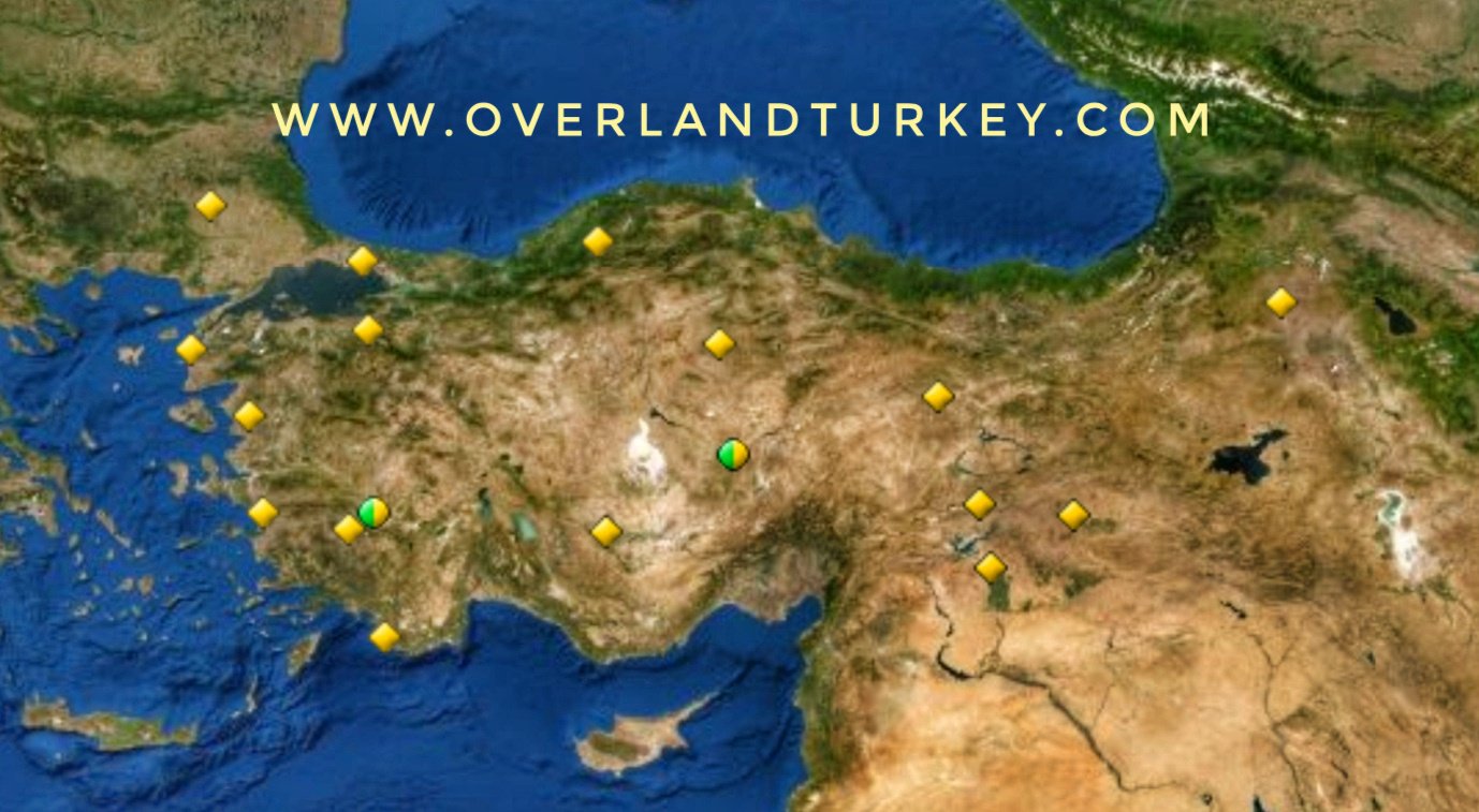
Unesco World Heritage Sites Turkey Tour (27 Days)
 Initial region
Turkey
Initial region
Turkey
 Duration
27 Days
Duration
27 Days
 Language
English
Language
English
 Price
€ 1.750 / person
Price
€ 1.750 / person
- Aphrodisias (2017)
- Archaeological Site of Ani (2016)
- Archaeological Site of Troy (1998)
- Bursa and Cumalıkızık: the Birth of the Ottoman Empire (2014)
- City of Safranbolu (1994)
- Diyarbakır Fortress and Hevsel Gardens Cultural Landscape (2015)
- Ephesus (2015)
- Göbekli Tepe (2018)
- Great Mosque and Hospital of Divriği (1985)
- Hattusha: the Hittite Capital (1986)
- Historic Areas of Istanbul (1985)
- Nemrut Dağ (1987)
- Neolithic Site of Çatalhöyük (2012)
- Pergamon and its Multi-Layered Cultural Landscape (2014)
- Selimiye Mosque and its Social Complex (2011)
- Xanthos-Letoon (1988)
- Göreme National Park and the Rock Sites of Cappadocia (1985)
- Hierapolis-Pamukkale (1988)
- Aslantepe Mound 2021
Day 1 Istanbul Airport Transfer
Your private guide meet you at airport and transfer you to hotel, meeting, welcome, briefing, short orientation tour
Overnight in Istanbul
Day 2 Istanbul city tour, Historic Areas of Istanbul
Historic Areas of Istanbul, After a weldone Turkish brealfast in hotel, we start our trip in Istanbul by walk. With its strategic location on the Bosphorus peninsula between the Balkans and Anatolia, the Black Sea and the Mediterranean, Istanbul has been associated with major political, religious and artistic events for more than 2,000 years. Its masterpieces include the ancient Hippodrome of Constantine, the 6th-century Hagia Sophia and the 16th-century Süleymaniye Mosque, all now under threat from population pressure, industrial pollution and uncontrolled urbanization.
Overnight in Istanbul
Day 3 Istanbul city Tour, Historic Areas of Istanbul
Today we will visit the Topkapi Palace, the understated but sumptuous home of generations of Ottoman Sultans.
The palace contains many treasures and holy relics. We continue visiting the unique Basilica Cistern, an underground sea of classical columns, built to hold water for the city when the aqueducts failed. In the afternoon we walk to Galata tower and drive to Sabancı Sarıkosk for an exhibition and dinner in Sarı Kosk
Overnight in Istanbul
Day 4 Drive to Edirne And Visit Selimiye Mosque and its Social Complex
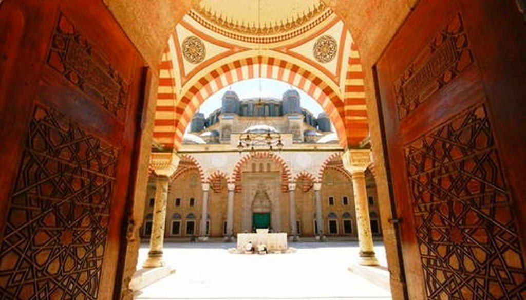
Today we leave Istanbul towards Edirne. We drive three hours 239 km and start our visit Selimiye Mosque and its Social Complex. The square Mosque with its single great dome and four slender minarets, dominates the skyline of the former Ottoman capital of Edirne. Sinan, the most famous of Ottoman architects in the 16th century, considered the complex, which includes madrasas (Islamic schools), a covered market, clock house, outer courtyard and library, to be his best work. The interior decoration using Iznik tiles from the peak period of their production testifies to an art form that remains unsurpassed in this material. The complex is considered to be the most harmonious expression ever achieved of the Ottoman külliye, a group of buildings constructed around a mosque and managed as a single institution. Today we sleep in Edirne
Overnight in Edirne
Day 5 Archaeological site of Troy
Today we drive to Canakkle and enroute visit Gallipoli where ww one settled in Turkey. Later on we visit in the late afternoon Troy. Troy, with its 4,000 years of history, is one of the most famous archaeological sites in the world. The first excavations at the site were undertaken by the famous archaeologist Heinrich Schliemann in 1870. In scientific terms, its extensive remains are the most significant demonstration of the first contact between the civilizations of Anatolia and the Mediterranean world. Moreover, the siege of Troy by Spartan and Achaean warriors from Greece in the 13th or 12th century B.C., immortalized by Homer in the Iliad, has inspired great creative artists throughout the world ever since.
The Archaeological Site of Troy has 4,000 years of history. Its extensive remains are the most significant and substantial evidence of the first contact between the civilizations of Anatolia and the burgeoning Mediterranean world. Excavations started more than a century ago have established a chronology that is fundamental to the understanding of this seminal period of the Old World and its cultural development. Moreover, the siege of Troy by Mycenaean warriors from Greece in the 13th century B.C., immortalized by Homer in The Iliad, has inspired great artists throughout the world ever since.
Troy is located on the mound of Hisarlık, which overlooks the plain along the Turkish Aegean coast, 4.8 km from the southern entrance to the Dardanelles. The famous archaeologist Heinrich Schliemann undertook the first excavations at the site in 1870, and those excavations could be considered the starting point of modern archaeology and its public recognition. Research and excavations conducted in the Troia and Troas region reveal that the region has been inhabited for 8,000 years. Throughout the centuries, Troy has acted as a cultural bridge between the Troas region and the Balkans, Anatolia, the Aegean and Black Sea regions through migration, occupation, trade and the transmission of knowledge.
24 excavation campaigns, spread over the past 140 years, have revealed many features from all the periods of occupation in the citadel and the lower town. These include 23 sections of the defensive walls around the citadel, eleven gates, a paved stone ramp, and the lower portions of five defensive bastions. Those archaeological remains date for the most part from Troy II and VI; however, a section of the earliest wall (Troy I) survives near the south gate of the first defences. In the last 15 years, it has become clear that a Lower City existed south of the mound in all prehistoric periods and extended to about 30 ha in the Late Bronze Age. Several monuments, including the temple of Athena and the recently excavated sanctuary, are part of the Greek and Roman city of Ilion, at the site of Troy. The Roman urban organization is reflected by two major public buildings on the edge of the agora (central market place), the odeion (concert hall) and the nearby bouleuterion (council house).
The surrounding landscape contains many important archaeological and historical sites, including prehistoric settlements and cemeteries, Hellenistic burial mounds, monumental tumuli, Greek and Roman settlements, Roman and Ottoman bridges and numerous monuments of the Battle of Gallipoli.
We sleep today in Canakkle
Overnigt in Canakkale
Day 5 Bursa and Cumalıkızık: the Birth of the Ottoman Empire
After leaving Canakkle, we drive along marmara sea and reach Bursa.This property is a serial nomination of eight component sites in the City of Bursa and the nearby village of Cumalıkızık, in the southern Marmara region. The site illustrates the creation of an urban and rural system establishing the Ottoman Empire in the early 14th century. The property embodies the key functions of the social and economic organization of the new capital which evolved around a civic centre. These include commercial districts of khans, kulliyes (religious institutions) integrating mosques, religious schools, public baths and a kitchen for the poor, as well as the tomb of Orhan Ghazi, founder of the Ottoman dynasty. One component outside the historic centre of Bursa is the village of Cumalıkızık, the only rural village of this system to show the provision of hinterland support for the capital.
Located on the slopes of Uludağ Mountain in the north-western part of Turkey, Bursa and Cumalıkızık represent the creation of an urban and rural system establishing the first capital city of the Ottoman Empire and the Sultan’s seat in the early 14th century. In the empire’s establishment process, Bursa became the first city, which was shaped by kulliyes, in the context of waqf (public endowments) system determining the expansion of the city and its architectural and stylistic traditions.
The specific development of the city emerged from five focal points, mostly on hills, where the five sultans (Orhan Ghazi, Murad I, Yıldırım Bayezid, Çelebi Mehmed, Murad II) established public kulliyes consisting of mosques, madrasahs (school), hamams (public baths), imarets (public kitchens) and tombs . These kulliyes, featuring as centres with social, cultural, religious and educational functions, determined the boundaries of the city. Houses were constructed near the kulliyes, turning into neighborhoods surrounding the kulliyes within the course of time. Kulliyes were also related with rural areas due to the waqf system. For example, the aim of Cumalıkızık as a waqf village, meaning that it permanently belonged to an institution (a kulliye), was to provide income for Orhan Ghazi Kulliye, as stated in historical documents.
The exceptional city planning methodology is expressed in the relationship of the five sultan kulliyes, one of which constitutes the core of the city’s commercial centre, and Cumalıkızık which is the best preserved waqf village in Bursa. This methodology developed during the foundation of the first Ottoman capital in early 14th century and expanded until the middle of the 15th century.
Overnight in Bursa
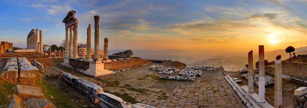
Day 6 Pergamon and its Multi-Layered Cultural Landscape
After leaving bursa we drive via Soma to Pergamon.This site rises high above the Bakirçay Plain in Turkey’s Aegean region. The acropolis of Pergamon was the capital of the Hellenistic Attalid dynasty, a major centre of learning in the ancient world. Monumental temples, theatres, stoa or porticoes, gymnasium, altar and library were set into the sloping terrain surrounded by an extensive city wall. The rock-cut Kybele Sanctuary lies to the north-west on another hill visually linked to the acropolis. Later the city became capital of the Roman province of Asia known for its Asclepieion healing centre. The acropolis crowns a landscape containing burial mounds and remains of the Roman, Byzantine and Ottoman empires in and around the modern town of Bergama on the lower slopes.
Pergamon was founded in the 3rd century BC as the capital of the Attalid dynasty. Located in the Aegean Region, the heart of the Antique World, and at the crossroads between Europe and the Middle East, it became an important cultural, scientific and political centre. Creation of the capital on top of Kale Hill set the scene for the city. High steep sloping terrain and the Bakırçay Plain were integrated into the urban plan. The exceptional composition of monuments includes the extremely steep theatre, the lengthy stoa, a three-terraced Gymnasium, the Great Altar of Pergamon, the tumuli, pressured water pipelines, the city walls, and the Kybele Sanctuary which was perfectly aligned with Kale Hill. As the Attalid capital, Pergamon was the protector of cities in the Hellenistic Period. It had political and artistic power and built up a very intense relationship with its contemporary civilisations. The dynasty founded one of the largest libraries in Pergamon, and the rivalry between three Hellenistic dynasties caused the Attalid Dynasty to create the famous sculpture school.
After the city was passed to the Romans in 133 BC, Pergamon became a metropolis and was the capital of the Roman Province of Asia during the Roman imperial period. The Romans maintained the already existing structures of the Hellenistic Period while adding new functions as a cultural and imperial cult centre of the empire. Consequently, during the Roman Period, many important structures were built or further developed, including the Asclepion Sanctuary, a well-known healing centre whose sacred spring still flows; the Roman Theatre; one of the largest Roman amphitheatres; a great aqueduct; the Trajan Temple and the Serapeum. During the Byzantine Period due to the relocation of the trade roads and political centres from the Aegean Region to northwest Anatolia, especially to İstanbul (Constantinople), Pergamon was transformed from a major Hellenistic and Roman centre into a middle-sized town, and continued its cultural-religious importance as home to one of the Seven Churches of Asia. Pergamon now preserves and presents this transformation.
After the arrival of the Ottomans, Pergamon experienced one more cultural adjustment, which is especially evident on the Bakırçay Plain. The Ottomans provided the city with all necessary urban structures, such as mosques, baths, bridges, khans, bedestens (covered bazaars), arastas (Ottoman markets) and water systems overlaying the Roman and Byzantine settlement layers. The superimposition of all these different periods and cultures through continuous habitation in Pergamon, finds its reflection in Pergamon’s urban form and architecture as continuities, formations, transformations and losses due to the material existence and use of space by different eras and cultures. The re-use of structures by later cultures is particularly demonstrated by the Church of St. John, formerly part of the Serapeum, a sanctuary dedicated by the Romans to an Egyptian deity. It subsequently became an Ottoman Mosque as well as incorporating a Jewish Synagogue.
From the 3rd century BC onwards, the city was encircled by a ring of grave mounds of various sizes, which demonstrated Pergamon’s claim to the plain of Bakırçay. In addition to grave mounds, there were sanctuaries, such as the Kybele Sanctuary at Kapıkaya, sited on prominent hills and mountain peaks in the area surrounding the city. Pergamon is a testimony to the unique and integrated aesthetic achievement of the civilizations. It incorporates Hellenistic, Roman, Byzantine and Ottoman structures, reflecting Paganism, Christianity, Judaism and Islam; preserving their cultural features within the historical landscape.
We drive to Selcuk, Ephesus for Overnight
Day 7 Ephesus
Ephesus Day.The great harbour of Asia Minor, Ephesus has a multi-layered history, in fact the city moved several times. A centre of Mother-God worship, first the Anatolian Mother Goddess Cybele, The Greek Goddess Artemis and later the Virgin Mary were venerated here. Another of the Seven Churches, Ephesus had a large Jewish community who converted to Christianity early, encouraged by St John the Apostle who spent time here. Ephesus is very well preserved and excavated, the Roman civic design is clear. Walk from the council chamber all the way to the library, across to the theatre and down the 'Arcadian Way' to where the harbour was. After visiting the newly renovated museum and St. John Basilica.Located within what was once the estuary of the River Kaystros, Ephesus comprises successive Hellenistic and Roman settlements founded on new locations, which followed the coastline as it retreated westward. Excavations have revealed grand monuments of the Roman Imperial period including the Library of Celsus and the Great Theatre. Little remains of the famous Temple of Artemis, one of the “Seven Wonders of the World,” which drew pilgrims from all around the Mediterranean. Since the 5th century, the House of the Virgin Mary, a domed cruciform chapel seven kilometres from Ephesus, became a major place of Christian pilgrimage. The Ancient City of Ephesus is an outstanding example of a Roman port city, with sea channel and harbour basin.
Overnight in Selcuk, Ephesus
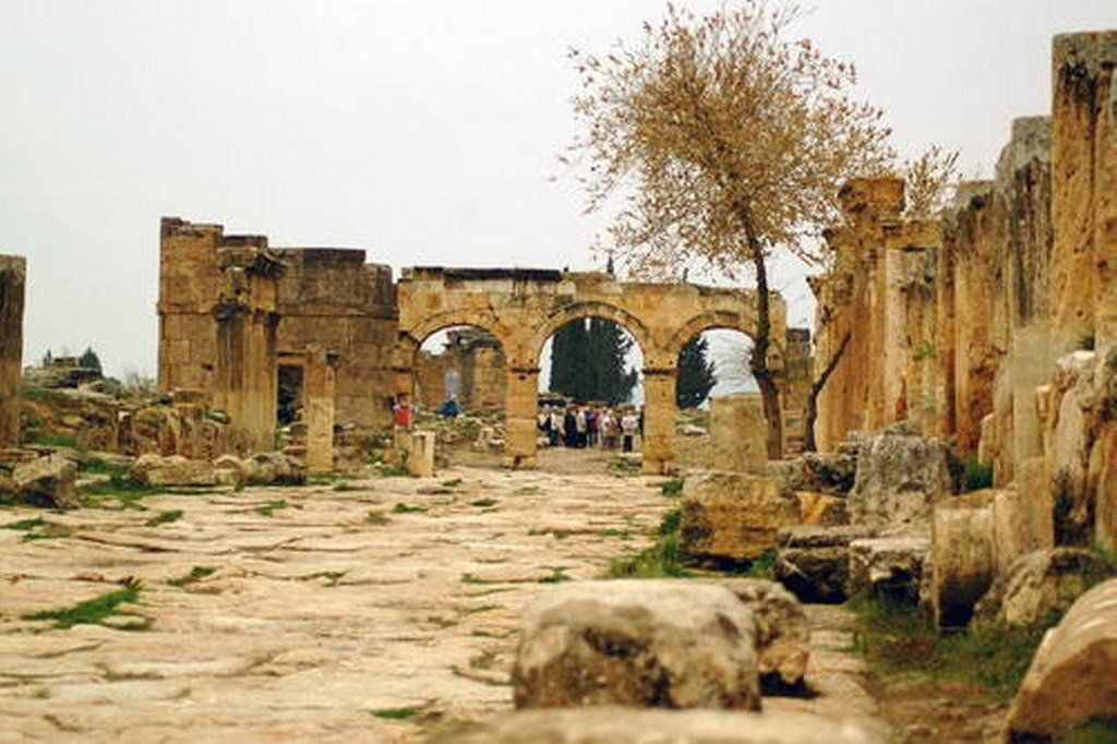
Day 8 Drive to Aphrodisias and Pamukkale, Hierapolis-Pamukkale
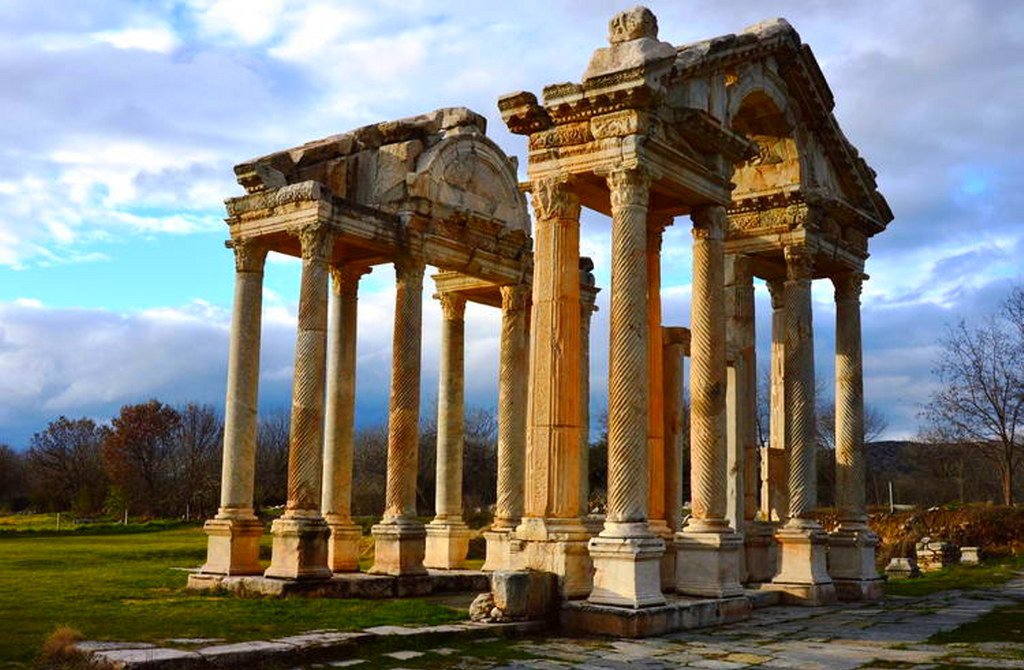
After 2 hours drive we reach Aphrodisias which is located in southwestern Turkey, in the upper valley of the Morsynus River, the site consists of two components: the archaeological site of Aphrodisias and the marble quarries northeast of the city. The temple of Aphrodite dates from the 3rd century BC and the city was built one century later. The wealth of Aphrodisias came from the marble quarries and the art produced by its sculptors. The city streets are arranged around several large civic structures, which include temples, a theatre, an agora and two bath complexes. Later in the evening, we arrive Pamukkale deriving from springs in a cliff almost 200 m high overlooking the plain, calcite-laden waters have created at Pamukkale (Cotton Palace) an unreal landscape, made up of mineral forests, petrified waterfalls and a series of terraced basins. At the end of the 2nd century B.C. the dynasty of the Attalids, the kings of Pergamon, established the thermal spa of Hierapolis. The ruins of the baths, temples and other Greek monuments can be seen at the site.
Overnight in Pamukkale
Day 9 Travel To Xanthos and Letoon and Overnight in Patara
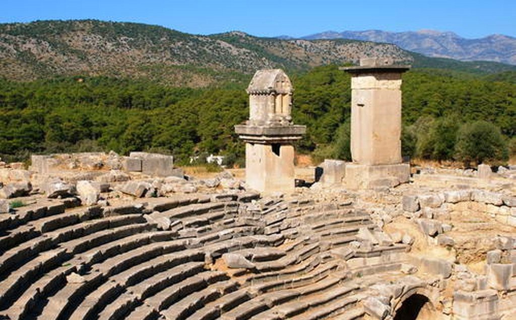
We leave Pamukkale and depart to Xanthos and Letoon. This site, which was the capital of Lycia, illustrates the blending of Lycian traditions and Hellenic influence, especially in its funerary art. The epigraphic inscriptions are crucial for our understanding of the history of the Lycian people and their Indo-European language.
Made up of two neighboring settlements located in the southwestern part of Anatolia, respectively within the boundaries of Antalya and Muğla Provinces, Xanthos-Letoon is a remarkable archaeological complex. It represents the most unique extant architectural example of the ancient Lycian Civilization, which was one of the most important cultures of the Iron Age in Anatolia. The two sites strikingly illustrate the continuity and unique combination of the Anatolian, Greek, Roman, and Byzantine civilizations. It is also in Xanthos-Letoon that the most important texts in Lycian language were found. The inscriptions engraved in rock or on huge stone pillars on the site are crucial for a better understanding of the history of the Lycian people and their Indo-European language.
Xanthos, which was the capital of ancient Lycia, illustrates the blending of Lycian traditions with the Hellenic influence, especially in its funerary art. The rock-cut tombs, pillar tombs and pillar-mounted sarcophagi in Xanthos are unique examples of ancient funerary architecture. Their value was already recognized in Antiquity and they influenced the art of neighboring provinces: the Mausoleum of Halicarnassus is for instance directly influenced by the Xanthos Nereid Monument. The fact that some architectural and sculptural pieces of the sites were taken to England in the 19th century, including the Monument of Harpy, the Tomb of Payava and the Nereid Monument, led to their word-wide recognition, and consequently the Xanthos marbles became an important part of the history of ancient art and architecture.
East of the Xanthos River (Eşen Çayı), the first monumental zone includes the old Lycian Acropolis, which was remodeled during the Hellenistic and Byzantine periods. At that time, a church was built at the northeast corner, while an advanced defensive structure fortified the western side of the citadel along the river. Directly north of the Acropolis stands a very beautiful theatre that dominates the Roman agora. This area also features great Lycian funerary monuments imitating woodwork, which are characteristic of the archaeological landscape of Xanthos and rise up spectacularly from the ruins. There is a second, more complex archaeological zone that extends between the Vespasian Arch to the south and the Hellenistic Acropolis to the north. The lower part of the town, which includes the Hellenistic Agora and Byzantine churches, was located in this part of the site.
Letoon, on the other hand, was the cult center of Xanthos, the ancient federal sanctuary of the Lycian province and Lycian League of Cities. As many inscriptions found at the site demonstrate, the federal sanctuary was the place where all religious and political decisions of the ruling powers were declared to the public. The famous trilingual inscription, dating back to 337 B.C., features a text inLycian and Greek as well as an Aramaic summary and was discovered near the temple of Apollo. In the sanctuary of Letoon, three temples are dedicated to Leto, Artemis and Apollo. In addition, the site includes the ruins of a nymphaeum dating back to Hadrian, built on a water source that was considered sacred.
Overnight in Patara
Day 10 Patara and Kas , free Afternoon ideal place to rest half day
After morning visit in Patara and enjoying the sand dunes, here we continue on to Kas, one of the nicest towns of the Turkish coast for some relaxation and perhaps a swim in the sea.
Overnight in Kas
Day 11 Antalya old Town, Aspendos, Ibradi
Today we leave Kas and head to Antalya. We will walk through the main shopping steet, take a look at old city walls, go down to the old town, walk through main historical sights. You will see all the beautiful places of The heart of Antalya. Walk through a beautiful park with wonderful views of the Harbour. We visit Yivli minaret, Hadrians Gate. Then drive to Aspendos.
The ancient city of Aspendos is located in Southern Turkey, in the ancient Pamphylia region by the Eurymedon (Köprüçay) river. The acropolis lies about 60 m. above sea level and sits on a flat-topped hill with many surviving monuments including the Nymphaeum, Basilica, Market Building and Odeion.
The Eurymedon used to be a navigable river and gave access to the city. This was the main reason for the city‟s prosperity. Both the archaeological remains and the historical sources confirm that Aspendos had entered upon the stage of ancient world events by the 5th century BC with the arrival of the Persians to Pamphylia and that it continued to retain its importance until, and after, Alexander‟s control of Asia Minor.
The earlier archaeology is currently being investigated, and recent findings carried the history of the city back even further. Recent surveys and excavations brought up material cultures from the Early Iron Age. The monumental buildings are mainly from the Hellenistic and Roman Period. Currently, it is known that there was continuous settlement right through to the Byzantine and Seljuk periods.
The site is visited by approximately 400.000 people every year, mainly because of its magnificent Roman theatre. “This is not like anything that I ever saw before.” This is how the British archaeologist David George Hogarth had described the Aspendos Theatre in 1909 in a paragraph which continues as follows: “You may have seen the amphitheatres in Italy, France, Dalmatia and Africa; temples in Egypt and Greece; the palaces in Crete; you may be sated with antiquity or scornful of it. But you have not seen the theatre of Aspendos.”
This description is still valid today, because the site of Aspendos houses the best preserved ancient theatre of the world. In addition, this richly decorated monument bears the traces of different historic periods including the Roman and the Seljuk periods. It was initially built during the reign of the Roman emperor Marcus Aurelius, between 160-180 A.D. The inscription on the western entrance wall records that the architect was Zenon, son of Theodorus and it was the gift of two rich brothers; A.Curtius Crispinus Arruntianus and A.Curtius Crispinus.
Like most theatres in Asia Minor, the majority of the cavea or spectator tribune is dug out of the eastern slope of the acropolis whereas the rest is supported by artificial subtractions, a stone-built arch and vault system.
The monument is among the biggest of its kind, with a façade of approximately 100 meters wide and 22 meters high. What makes it unique is the impressive level of preservation and the richness of its architectural decorations. The new investigations have revealed that the capacity of the theatre was 7300-7600 people (45cm seating width per person). This number could be up to 8500 people, if stairs had been used as seat places in crowded performances in Ancient Times. The cavea is divided in two parts by a horizontal passage called the diazoma. The lower section contains 20 rows of seat, while the upper one has 21 rows. The main entrances to the lower cavea are through two vaulted parodoi, linking the stage building to the cavea. The actual scaenae frons or stage is flanked by two towers, providing access to the seating rows situated higher up in the auditorium. In addition, a system of gates in the exterior wall of the cavea provided additional options to access the cavea. Unique also is the covered gallery raised above the whole perimeter of the cavea, offering shelter from the elements to those who wished to take a brake from the spectacles. Although partially reconstructed, it is the best preserved example in Asia Minor and beyond.
The two-storied stage building, which is adorned with exquisite architectural ornamentation, still stands to its full height. The stage was accessed through five doors. The central gate is the largest one and is flanked by two doors of decreasing dimensions on either side. Projecting socles, separating the doors from one another, are still preserved. The formed the basis for the two-storied aediculated façade that formed the background of the actual stage for the actors, which is no longer preserved and was probably dismantled when the function of the building changed in post antique times. The façade itself was magnificently decorated and composed of highly decorated entablatures supported by monolithic columns. The friezes of the lower storey were decorated with garlands hung from bucrania, whereas a tendril frieze decorated those of the upper storey. They supported equally richly carved cornices, which were in their turn crowned by differently shaped pediments. In the middle over the central gate, the façade culminated in a large-scale relief. Although the fronts of the protruding elements of the façade are no longer there, the remaining elements still provide an excellent idea of the original monumental façade. The monument is also of extreme importance for understanding the use of acoustics in ancient theatres. The stage building of Aspendos Theatre was probably covered by a wooden roof, which has not survived. Seljuk restoration in the 13th century and the reuse of the monument as a palace for a short period during the time of Sultan Alaeddin Keykubat aided the preservation of this magnificent structure. The zigzag paintings in red, which are still visible today on many surfaces of the internal and external façade, are dated to this period. Additionally, some of the windows on the inner part of the stage building were converted into gates to provide access to the southern part of the structure from the north tower.
Although mainly known for its theatre by the general public and visitors, Aspendos‟ aqueducts, with their two unique siphons, have been a source of extreme fascination for researchers. The aqueducts brought water to the city from the mountains 15 km to the north. The water, which was carried by the arcades, and at some points by the underground pipe drains, was vital not only for Aspendos but for the whole of the Pamphylian plain. It was thanks to this water that the city and its rural surroundings were fertile and rich in grain. The water was brought to the city centre by means of this aqueduct from two sources, namely Gökçeler and Pınarbaşı at about 500 m above sea level and 19 km away. Bean suggests, after study of an epigraphic source, that the Aspendos‟ aqueducts were erected by Tiberius Claudius Italicus at a cost of 2 million Denarii in the second century AD. The inverted siphons of the aqueduct, which are approximately 30 m high, made it possible to cross the 1.7km wide valley between the mountains to the north and the acropolis. The inner dimensions of the water channels were 55-60 cm wide and 90 cm high. The water channels of the siphons are of stone. The siphons rise at an angle of 55 degrees and the 924 m distance between them is traversed by arches that are 5.5 m wide space. The arches are 15 m high in the deepest point of the valley.
This structure, with these measurements and in its current condition, is one of the highest Roman constructions. Aspendos‟ aqueducts are similar to two structures, which are already on the UNESCO World Heritage List: the Pont du Gard aqueducts, which are higher than the one in Aspendos with a height of 48.77 meters; and the aqueducts of Segovia in Spain, which are 28.5 meters.
However none of these structures contain the siphons, which are extremely well preserved at Aspendos. Similar siphons can be found in Lyon (Mont d‟Or, Brévenne and Gier), however these do not provide any insight into their building technique or the use of these structures. The siphons in Aspendos allow researchers to make further discoveries on how it might have functioned. Moreover, the length of the still standing aqueducts of Aspendos is more than the ones in Segovia and Pont du Gard.
We Sleep in Ibradi.
Day 12 Drive to Neolithic Site of Catalhotuk and Stay in Aladaglar National Park
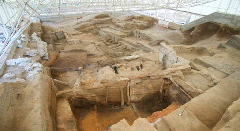
We leave Ibradi and drive to Catalhoyuk. Two hills form the 37 ha site on the Southern Anatolian Plateau. The taller eastern mound contains eighteen levels of Neolithic occupation between 7400 bc and 6200 bc, including wall paintings, reliefs, sculptures and other symbolic and artistic features. Together they testify to the evolution of social organization and cultural practices as humans adapted to a sedentary life. The western mound shows the evolution of cultural practices in the Chalcolithic period, from 6200 bc to 5200 bc. Çatalhöyük provides important evidence of the transition from settled villages to urban agglomeration, which was maintained in the same location for over 2,000 years. It features a unique streetless settlement of houses clustered back to back with roof access into the buildings.
Overnight in Aladaglar National Park
We can ovenight in Guest House, or Mountain National Park, or Camping in Tent
Day 13-14-15 Drive to Cappadocia via Nigde Gumusler Monastery, Kaymaklı Underground City and explore Cappadocia
In a spectacular landscape, entirely sculpted by erosion, the Göreme valley and its surroundings contain rock-hewn sanctuaries that provide unique evidence of Byzantine art in the post-Iconoclastic period. Dwellings, troglodyte villages and underground towns – the remains of a traditional human habitat dating back to the 4th century – can also be seen there.
Located on the central Anatolia plateau within a volcanic landscape sculpted by erosion to form a succession of mountain ridges, valleys and pinnacles known as “fairy chimneys” or hoodoos, Göreme National Park and the Rock Sites of Cappadocia cover the region between the cities of Nevşehir, Ürgüp and Avanos, the sites of Karain, Karlık, Yeşilöz, Soğanlı and the subterranean cities of Kaymaklı and Derinkuyu. The area is bounded on the south and east by ranges of extinct volcanoes with Erciyes Dağ (3916 m) at one end and Hasan Dağ (3253 m) at the other. The density of its rock-hewn cells, churches, troglodyte villages and subterranean cities within the rock formations make it one of the world's most striking and largest cave-dwelling complexes. Though interesting from a geological and ethnological point of view, the incomparable beauty of the decor of the Christian sanctuaries makes Cappadocia one of the leading examples of the post-iconoclastic Byzantine art period.
It is believed that the first signs of monastic activity in Cappadocia date back to the 4th century at which time small anchorite communities, acting on the teachings of Basileios the Great, Bishop of Kayseri, began inhabiting cells hewn in the rock. In later periods, in order to resist Arab invasions, they began banding together into troglodyte villages or subterranean towns such as Kaymakli or Derinkuyu which served as places of refuge.
Cappadocian monasticism was already well established in the iconoclastic period (725-842) as illustrated by the decoration of many sanctuaries which kept a strict minimum of symbols (most often sculpted or tempera painted crosses). However, after 842 many rupestral churches were dug in Cappadocia and richly decorated with brightly coloured figurative painting. Those in the Göreme Valley include Tokalı Kilise and El Nazar Kilise (10th century), St. Barbara Kilise and Saklı Kilise (11th century) and Elmalı Kilise and Karanlık Kilise (end of the 12th – beginning of the 13th century).
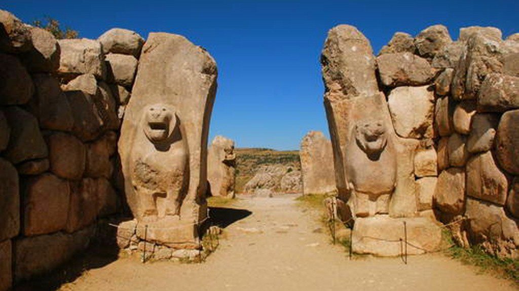
Day 16 Hittite capital Hattusha, their religious centre of Yazilikaya and the settlement of Alacahoyuk
We leave Cappadocia early morning and srive to Hattusha the Hittitie Capital City. The archaeological site of Hattusha, former capital of the Hittite Empire, is notable for its urban organization, the types of construction that have been preserved (temples, royal residences, fortifications), the rich ornamentation of the Lions' Gate and the Royal Gate, and the ensemble of rock art at Yazilikaya. The city enjoyed considerable influence in Anatolia and northern Syria in the 2nd millennium B.C.
The property consists of the Hittite city area, the rock sanctuary of Yazılıkaya on the north, the ruins of Kayalı Boğaz on the east and the İbikçam Forest on the south. A monumental enclosure wall of more than 8 km in length surrounds the whole city. There are remains of older walls around the lower city and section walls dividing the large city area in separate districts. The ruins of the upper city’s fortification form a double wall with more than a hundred towers and, as far as is known today, five gateways: two in the west, the Lion’s Gate in the south-west, the King’s Gate in the south-east and a procession gate, the Sphinx Gate in the south of the city. The latter is located on top of a high artificial bastion with stone-plastered slopes, with two staircases leading to the gateway at the top and an arched stone tunnel running underneath. The impressive ruins of fortifications, placed on rocky peaks in the centre of the Upper City, bear witness to the complexity of Hittite rock masonry, and the longest known Hittite hieroglyphic inscription from the Hittite Empire can be found in the Upper City at Nişantepe.
The best-preserved ruin of a Hittite Temple from the 13th century B.C., known as Great Temple, is located in the Lower City. Other temples of similar date and shape, albeit generally smaller, are situated in the Upper City, which mostly consisted of a temple city for the gods and goddesses of the Hittite and Hurrian pantheon. The remains of a densely inhabited city district were unearthed in the Lower City, where their foundations and arrangement can still be seen in the area north from Great Temple.
The famous rock sanctuary of Yazılıkaya, which is an open-air temple with two natural chambers cut into the bedrock, lies 2 km northeast of the capital, on a slope of a mountain barrier. The walls of the rock chambers are covered with the richest and most striking samples of Hittite relief art, featuring gods and goddesses and the figures of the Great King Tuthaliya IV. Kayalı Boğaz, first mentioned in cuneiform inscriptions, is a large fortified settlement located 1.5 km east of the King’s Gate. It may have served as one of the outposts and strongholds, located in the countryside to watch and control the main roads leading to the city. The İbikçam Forest represents one of the last remaining examples of a dense forest covering the mountains south of the capital in Hittite times.
Hattusha is an archaeological site remarkable for its urban organization, the types of construction and rich ornamentation that have been preserved and for the ensemble of rock art.
We drive to Safranbolu and overnight in Sarranbolu
Day 17 Sarfanbolu Amasra Ankara
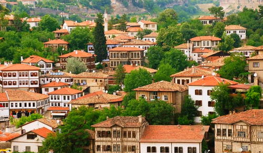
The City of Safranbolu is a typical Ottoman city, with typical buildings and streets, and played a key role in the caravan trade over many centuries. The settlement developed as a trading centre after the Turkish conquest in the 11th century, and by the 13th century, it had become an important caravan station. Its layout demonstrates the organic growth of the town in response to economic expansion, and its buildings are representative of its evolving socio-economic structure up to the disappearance of the traditional caravan routes and beyond.
Safranbolu consists of three distinct historic districts; the market place area of the inner city, known as Çukur, the area of Kıranköy, and Bağlar (the Vineyards). Çukur lies in the lower part of the town and has a triangular shape defined by two rivers. Its centre is the market place, surrounded by the houses and workshops of craftsmen. The segregation of the city centre is very typical for Anatolian cities. Kıranköy was formerly a non-Muslim district, with a socio-architectural pattern similar to that in contemporary European towns, with the artisans and tradesmen living above their shops. The houses in this district are built of stone, in contrast to the wooden houses in Çukur, which illustrates how the separation of Muslim and non-Muslim quarters during the Ottoman Period enabled each community to establish settlements according to their own traditions.
The pattern of settlement in Bağlar (the Vineyards) consists of single houses set within large gardens. This district on the northwest slope of the city, looking to the south, was the summer resort for the city.
The streets in Çukur and Kıranköy are narrow and curved, creating a wider view at the corners following topographic lines, and the various consoles of the houses contribute to creating interesting street perspectives. The streets feature stone paving, sloping inwards to evacuate surface water, and older houses are half-timbered, while the spaces between the timbers are filled with various building materials. There are no windows on the street frontage, so that stone walls resemble extensions of garden walls. The main rooms on the first floors are usually panelled with built-in cupboards, fireplaces, shelves and benches. Many of the ceilings are lavishly carved and painted. The rooms serve different purposes and are connected together with halls called “sofa”, which are very important elements of the house. From here we drive Ankara to take Eastern Express Train for our overnight train journey to Sivas.
Overnight Train Eastern Express
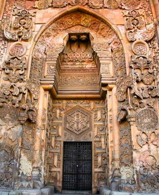
Day 18 Sivas Divrigi Ulu Camii, Great Mosque and Hospital of Divriği
This region of Anatolia was conquered by the Turks at the beginning of the 11th century. In 1228–29 Emir Ahmet Shah founded a mosque, with its adjoining hospital, at Divrigi. The mosque has a single prayer room and is crowned by two cupolas.The highly sophisticated technique of vault construction, and a creative, exuberant type of decorative sculpture – particularly on the three doorways, in contrast to the unadorned walls of the interior – are the unique features of this masterpiece of Islamic architecture.
We return back to Sivas and enjoy our dinner in local restaurants and w take Kurtalan Express to Diyarbakır abd overnight in Train.
Overnight in Kurtalan Express
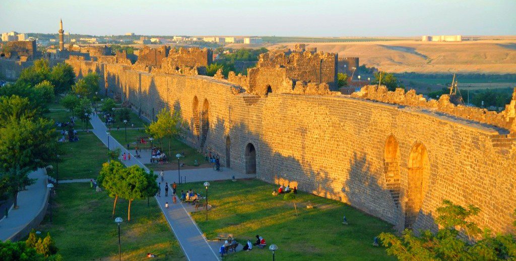
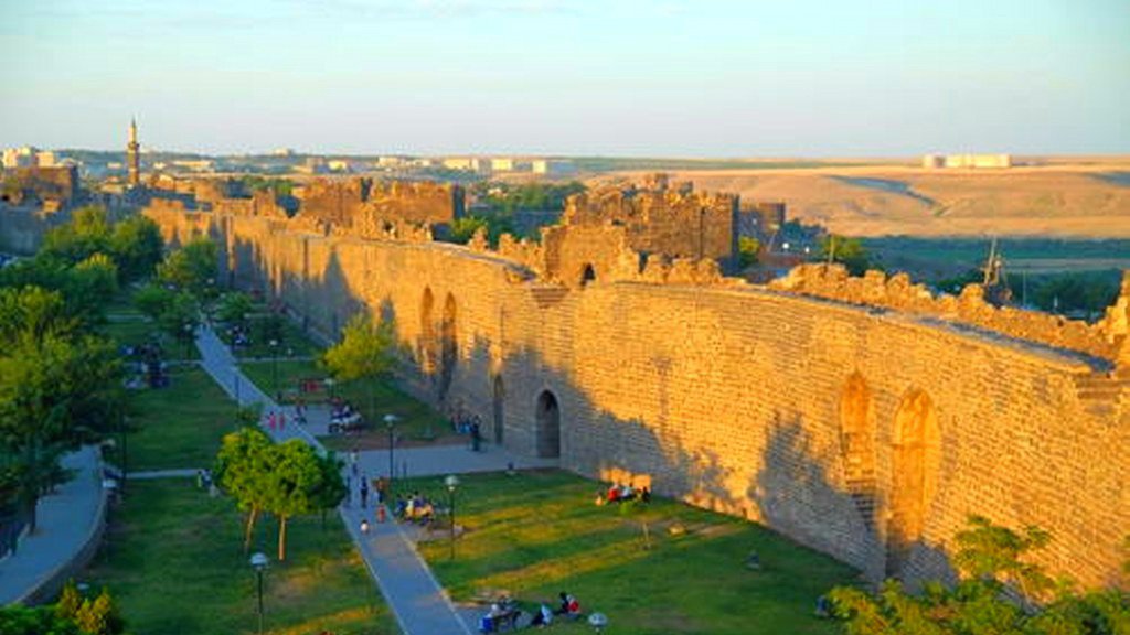
Day 19 Diyarbakır Fortress and Hevsel Gardens Cultural Landscape
Located on an escarpment of the Upper Tigris River Basin that is part of the so-called Fertile Crescent, the fortified city of Diyarbakır and the landscape around has been an important centre since the Hellenistic period, through the Roman, Sassanid, Byzantine, Islamic and Ottoman times to the present. The site encompasses the Inner castle, known as İçkale and including the Amida Mound, and the 5.8 km-long city walls of Diyarbakır with their numerous towers, gates, buttresses, and 63 inscriptions. The site also includes the Hevsel Gardens, a green link between the city and the Tigris that supplied the city with food and water, the Anzele water source and the Ten-Eyed Bridge.
Overnight in Diyarbakir
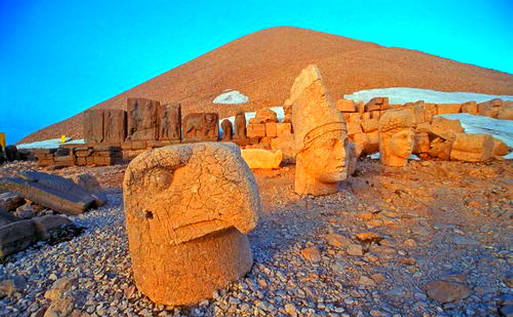
Day 20 Gobelitepe , Nemrut Mountain Arsemia Cendere Karakus Ephratues River Sunset Nemrut
We drive to Gobeklietepe, which is located in the Germuş mountains of south-eastern Anatolia, this property presents monumental round-oval and rectangular megalithic structures erected by hunter-gatherers in the Pre-Pottery Neolithic age between 9,600 and 8,200 BCE. These monuments were probably used in connection with rituals, most likely of a funerary nature. Distinctive T-shaped pillars are carved with images of wild animals, providing insight into the way of life and beliefs of people living in Upper Mesopotamia about 11,500 years ago. After a local lunch we continue Nemrut Dag, The mausoleum of Antiochus I (69–34 B.C.), who reigned over Commagene, a kingdom founded north of Syria and the Euphrates after the breakup of Alexander's empire, is one of the most ambitious constructions of the Hellenistic period. The syncretism of its pantheon, and the lineage of its kings, which can be traced back through two sets of legends, Greek and Persian, is evidence of the dual origin of this kingdom's culture.
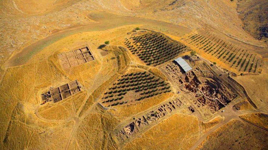
Arslantepe Mound
Arslantepe Mound is a 30-metre-tall archaeological tell located in the Malatya plain, 12 km south-west of the Euphrates River. Archaeological evidence from the site testifies to its occupation from at least the 6th millennium BCE up until the late Roman period. The earliest layers of the Early Uruk period are characterized by adobe houses from the first half of the 4th millennium BCE. The most prominent and flourishing period of the site was in the Late Chalcolithic period, during which the so-called palace complex was constructed. Considerable evidence also testifies to the Early Bronze Age period, most prominently identified by the Royal Tomb complex. The archaeological stratigraphy then extends to the Paleo-Assyrian and Hittite periods, including Neo-Hittite levels. The site illustrates the processes which led to the emergence of a State society in the Near East and a sophisticated bureaucratic system that predates writing. Exceptional metal objects and weapons have been excavated at the site, among them the earliest swords so far known in the world, which suggests the beginning of forms of organized combat as the prerogative of an elite, who exhibited them as instruments of their new political power.
Day 21 Nemrut Dag Sunrise, Malabadi Bridge, Ahlat Graves, Tatvan, Mt Nemrut Crater Lake
If weather doesnt permit the sunset previous day we reach to summit for sunrise. Later we continue driving to MAlabadi Bridge. Malabadi Bridge
The Historic Malabadi Bridge is located on the Batman Creek which disembogues to Dicle (Tigris) River at site of Çatakköprü within the district of Silvan on the border between the provinces of Diyarbakır and Batman. It is constructed at the narrowest section of the riverbed. The bridge is located approximately 104 km away from the modern city center of Diyarbakır, on the Ahlat highway which provides connection between the city of Diyarbakır via Van and Bitlis. The location of the bridge is also important as it is at the intersection point which provides connection to the northern Syria via Hasankeyf and Mardin as well as to the northern Mesopotamia through Midyat.
According to the epigraph dating to the year 1147, the bridge was constructed during Artuqids period and it was commissioned by Temür-tash of Mardin, son of Ilghazi and grandson of Artuq Bey. The bridge is deemed to be synthesized through the cultural accumulation attained by the Artuqids Dynasty, settled in Mardin, Diyarbakır and Hasankeyf, and the engineering - architectural genius of the northern Iran and the Antique and Medieval Age architecture in Anatolia. The bridge has survived with all its essential parts which has been functional since 12th century and is still in use for its original purpose today.
The bridge is the longest spanned stone arch bridge in the world with its pointed arch of 40.86m. Total length of the bridge is 281.67m., width 7.15 m. and a height, up to the keystone of the low water level is 24.50m. It also has five arches with the main arch at the middle. The efforts to settle the foundation of the bridge on the solid rocks caused an irregular geometry of the design. The span of the bridge crosses perpendicular to the river, but the roadway is at an angle to the river, so there are angular breaks in the east and west approaches. The approaches rise from ground level to meet the main span, which is a pointed arch high over the deepest part of the river. The arches of the bridge are bi-centered. There is an (0.40m height profile) ornamental belt (arşivolt) that continues along the main arch stone at 1.20 m height.
The bridge was built of ashlars and rubble stones of different size and dimensions. Brick was also used, especially for the construction of the vaulted ceiling of the chambers. In the bridge deck superstructure, chambers were built of brick vaults in order to relieve the pressure on the foundation. These chambers were also separately functioned. Evliya Çelebi, states in his travel book that there exist iron gates on both ends of the bridge in the form of portcullis and that travelers had to pay tribute tax when passing by the bridge. In addition, researchers, such as H. Von Moltke, Carl Ritter and A.Gabriel who travelled through Anatolia in 19th and 20th centuries contributed to provide important written and visual documents about the bridge.
Uprising as a continuity of spandrel walls, the parapets were constructed by the use of rough stone. To the upstream of the bridge, there exist triangularly shaped flood splitters while to the downstream side, such flood splitters are circular in form with pointed cones embroidered with human figures, lion and sun reliefs. The frontal pattern of the bridge is asymmetric. The bridge rises at an elevation of 12-20% up to the largest arch and descends at a rate of 17- 19% to Batman side which gives the bridge an environmentally harmonious shape.
Later we drive to mount Nemrut Crater lake, This geopgraphy houses lots of bears, we drive to Ahlat. Ahlat ,The Tombstones of Ahlat the Urartian and Ottoman citadel. Though the history of the city dates back to 900 BC, its famous for her tombstones dating to 12 th-15 th centuties AD. It has an important place inthe Islamic world in their variation within Anatolian tomb architecture in dimension and design. Apart from some small cemeteries here and there in Ahlat there are six main cemeteries of historical importance named; Harabe ~ehir cemetery, Taht~ Suleyman cemetery Klrklar cemetery, Kale cemetery, Merkez cemetery, Meydanl~k cemetery. Tombstones in Ahlat, some of the most outstanding tombstones and mausoleums of the early Turkish period in Anatolia are to be seen in Ahlat. These works are not only important sources of information on the technical and decorative repertoire of the period, but also act as historical sources for important maso ns and craftman, whose names appear in inscriptions there.
Overnight in Tatvan
Day 22 Akdamar Island, Akdamar Church Dogubeyazıt Ishakpasa Palace
Akdamar island and visit Akdamar church where there is a well documented Armenian church with the most ornate reliefs depicting scenes from the Old Testament.We take boat to visit it. Evening we arrive to Dogubeyazıt and check in to hotel. The Cathedral of the Holy Cross Turkish: Akdamar Kilisesi or Surp Haç Kilisesi, Armenian: Սուրբ Խաչ եկեղեցի , Surb Khach yekeġetsi) on Akdamar (Aghtamar) Island, in Lake Van in eastern Turkey, is a medieval Armenian Apostolic cathedral, built as a palatine church for the kings of Vaspurakan and later serving as the seat of the Catholicosate of Aghtamar. Ishak Pasha Palace on the Silk Route near the Iranian frontier, is situated on a high and vast platform of strategic importance on an area of 7600 meter square. It is not at all in the Ottoman tradition but is rather a mixture of Anatolian, Iranian and North Mesopotamian architectural tradition. The traditional model used in the construction of the Royal Palaces in the capital cities like Bursa, Edirne and Istanbul was taken as an example in the design of Ishak Pasha Palace. The western influence in Ottoman architecture during the post-classical period can be observed is Ishak Pasha Palace.
Overnight in Dogu Beyazıt View of Mount Ararat
Day 23 Drive around the foothills of Ararat, Noah's Ark, skirting the Armenian border, to Ani, abandoned medieval Armenian Capital. Over night in Kars.
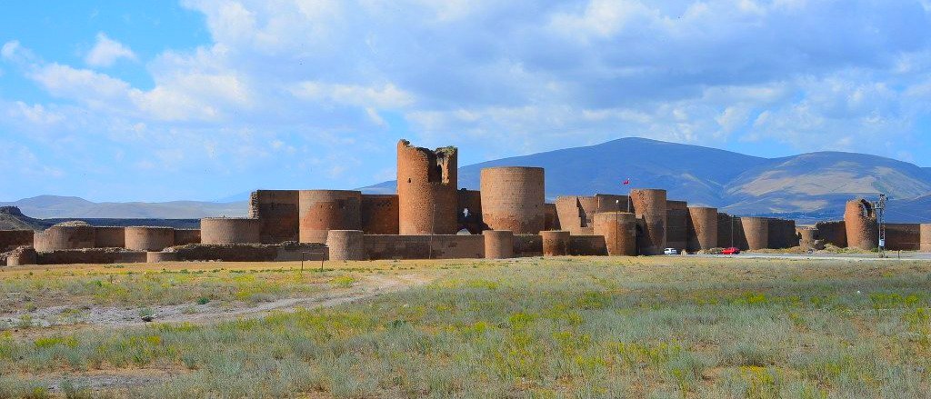
We visit Noah£s ark and drive to Kars via Tuzluca and Digor. We make tour of Tuzluca Salt Mine.Archaeological Site of Ani This site is located on a secluded plateau of northeast Turkey overlooking a ravine that forms a natural border with Armenia. This medieval city combines residential, religious and military structures, characteristic of a medieval urbanism built up over the centuries by Christian and then Muslim dynasties. The city flourished in the 10th and 11th centuries CE when it became the capital of the medieval Armenian kingdom of the Bagratides and profited from control of one branch of the Silk Road. Later, under Byzantine, Seljuk and Georgian sovereignty, it maintained its status as an important crossroads for merchant caravans. The Mongol invasion and a devastating earthquake in 1319 marked the beginning of the city’s decline. The site presents a comprehensive overview of the evolution of medieval architecture through examples of almost all the different architectural innovations of the region between the 7th and 13th centuries CE.
Ani is located in the northeast of Turkey, 42 km from the city of Kars, on a secluded triangular plateau overlooking a ravine that forms the natural border with Armenia. The continuity of settlement at Ani for almost 2500 years was thanks to its geographical location, on an easily defensible plateau that was surrounded by fertile river valleys at an important gate of the Silk Roads into Anatolia. This medieval city that was once one of the cultural and commercial centres on the Silk Roads, is characterized by architecture that combines a variety of domestic, religious and military structures, creating a panorama of medieval urbanism built up over the centuries by successive Christian and Muslim dynasties. Inhabited since the Bronze Age, Ani flourished in the 10th and 11th centuries AD, when it became a capital of the medieval Armenian kingdom of the Bagratids, and profited from control over one branch of the Silk Roads. Later, under Byzantine, Seljuk, and Georgian sovereignty, it maintained its status as an important crossroads for merchant caravans, controlling trade routes between Byzantium, Persia, Syria and Central Asia. The Mongol invasion, along with a devastating earthquake in 1319 and a change in trade routes, marked the beginning of the city’s decline. It was all but abandoned by the 18th century.
The principal area of the property consists of architectural remains located in three zones: the citadel, which includes the ruins of the Kamsaragan palace, Palace church, Midjnaberd church, Sushan Pahlavuni church, the Karamadin church and the church with Six Apses; the outer citadel or walled city which includes amongst others the Fire Temple, Cathedral, Ramparts of Smbat II, Emir Ebu’l Muammeran Complex, Seljuk Palace, domestic architecture, the market, and the Silk Road Bridge; and the area outside the city walls. Rock-carved structures on the slopes of one of the valleys surrounding the city, the Bostanlar Creek, are also part of the property.
Religious monuments of Zoroastrian, Christian and Muslim influence, as well as public and domestic buildings in Ani provide a vivid and comprehensive picture of a distinctive relic medieval city which attests to the transmission and amalgamation of different architectural traditions that evolved in the Caucasus, Iran, Turkestan and Khorasan, and were translated into stone. This medieval settlement consists of remains from a multi-cultural centre, with all the richness and diversity of Medieval Armenian, Byzantine, Seljuk and Georgian urbanism, architecture, and art development.
Day 24 Tour of Kars
Option 1 You could end the tour and fly from Kars Airport
Option 2 You could connect your tour to Georgia or Armenia or Iran from here
Option 3 Continue to Trabzon via Arhavi Artvin, Discover the Blacksea Region
Day 25 Drive to Arhavi, Enroute we visit Savsat Karagol, Ardahan Devils Castle, Arhavi Tea Farm, Cifte Pugar Tea Farmers Village
Drive to Arhavi, Enroute we visit Savsat Karagol, Ardahan Devils Castle, Arhavi Tea Farm, Cifte Pugar Tea Farmers Village and arrive to Arhavi
Overnight in Arhavi
Day 26 Visit Mencuna Waterfall, Visit Tea Factory, Drive to Trabzon visit Hagia Sofia of Trabzon
Visit Mencuna Waterfall, Visit Tea Factory, Drive to Trabzon visit Hagia Sofia of Trabzon. We check in hotel in Trabon
Day 27 Airport Transfer to Trabzon Airport
Tour ends
- Private Guide
- Private Driver
- All hotel Accomodation as it is in trip notes
- All Breakfasts
- Museum Pass Card
- Petrol Taxes
- Guide and Driver's expenses
- Parking tickets, insurance and taxes.
- Personal expenses
- Lunch & Dinners
- Drinks
- Tips
PRICE DETAILS
1 Person in Single room: 7500 € Per person
2 Person sharing room:3950 € Per person
3 Person, 2 sharing and 1 Single: 3275 € Per person
4 Person sharing 2 rooms: 3000 € Per person.
5 + Person 2750 € per person
PLEASE CONTACT US FOR DETAILS LET US CUSTOMISE YOUR BEST TURKEY TOUR
DONT MISS OUR DISCOUNTS FOR LARGER GROUPS
TRAVEL AGENCIES AND TOUR GROUPS WITH TOUR LEADERS GET % 10 DISCOUNTS
PLEASE DONT HESITATE TO ASK US FOR ALL QUESTIONS
BESPOKE OVERLAND TURKEY TOUR
-
Best Tour Guide Ever
I put together list of 7 places I wanted to see in Turkey and then Tolga from Overland Travels turned my list into a real itinerary. He arranged a driver, a very comfortable touring van, hotels, a domestic flight, meals and tours of all sites. One site was closed for COVID and Tolga called the manager of the site and arranged a personalized tour. My weeklong trip could not have been better. Tolga spoke perfect English and knew the history of every site from beginning to present. We covered Hattusa, Divrigi, Diyarbakir, Mt. Nemrut, Gobekli Tepi, Xanthos, Letoon, Patara and even spent time in Ankara and Fethiye. He even added an extra UNESCO site to my itinerary at no extra cost because her knew I would be interested. We toured, ate and talked history for one of the best weeks of my life.
J.N. Published 2020-09-02